
Page 71 - Demo
P. 71
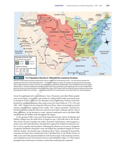
CHAPTER 7 Hammering Out a Federal Republic, 1787%u20131820 273horses by supplying food to Assiniboines, Crees, Cheyennes, and other Plains peoples and secured guns, iron goods, and textiles by selling buffalo hides and dried meat to European traders. However, the Mandans (and neighboring Arikaras) had been hit hard by smallpox epidemics that swept across the Great Plains in 1779%u20131781 and 1801%u20131802. Their towns lay along the Missouri River, where increasingly powerful Lakotas and Yanktons regulated river traffic. The %u201cLakota meridian%u201d extended for hundreds of miles along the Missouri, and Lewis and Clark could pass upriver only at their sufferance. In the decades to come, Lakotas would push west to the Black Hills and dominate the buffalo trade throughout the region.In the spring of 1805, Lewis and Clark departed from the cluster of Mandan and Hidatsa villages near the Knife River to begin an epic 1,300-mile trek to the Pacific. They hired a French Canadian fur trader, Toussaint Charbonneau, and Sacagawea, a sixteen-year-old Lemhi Shoshone who had been captured by Arikaras several years earlier, to serve as guides and translators. Following the Missouri to its source, Sacagawea recognized landmarks along their route and helped the expedition bargain for horses with her brother, who had become a Shoshone chief. Then, venturing far beyond the Louisiana Purchase, they traveled down the Columbia River to the Pacific Ocean. In 1806, Lewis and Clark presented Jefferson with the first maps of the immense territory and a detailed account of its natural resources and inhabitants (Map 7.3). Their report prompted some Americans to envision a nation that would span the continent.LYNPAUFort MissionPike, 1806%u20131807Population Density, 1800U.S. nationals per sq. mileLewis and Clark, 1804%u2013180618 to 45Over 45Explorers%u2019 RoutesPike, 1805%u20131806Under 22 to 180 250 500 kilometers0 250 500 milesNSEWColumbia R.Snake R.Red R.Arkansas R.Mississippi R.Ohio R.L. ErieL. OntarioL. HuronL. MichiganL. SuperiorATLANTICOCEANGulf of MexicoRio GrandePACIFICOCEANColorado R.Missouri R.CROWGROS VENTRECHEYENNESANTEESIOUX IOWAARAPAHOKANSAKIOWAWICHITAMISSOURIKICKAPOOPOTAWATOMIDELAWAREILLINOIS MIAMISAUKFOXOSAGESHAWNEEWSEHO-CHUNKCHICKASAWNATCHEZCHOCTAWMUSCOGEECHEROKEECHYUCHITIMUCUASEMINOLEALTACALIFORNIAOREGON(Claimed by Britain, Spain,and the United States)NEWLOUISIANA PURCHASEINDIANATERRITORY OHIOTENN.MISSISS GA. IPPITERRITORYS.C.N.C.VA.MD.PA.N.Y.DEL.N.J.CONN.MASS.VT.N.H.ME.(MASS.)R.I.S PA N I S HF L O R I DACOAHUILAUPPERCANADALOWERCANADARUPERT%u2019S LANDTEXASKY.CUBASPAINSan FranciscoSan Luis ObispoSanta BarbaraLos AngelesSan DiegoChihuahuaEl PasoSanta FeTaosSan AntonioNacogdochesSt. LouisNew OrleansamerhistoryHS11e_07_m03Louisiana Purchase43p3 x 28p6First Proof02/15/24MAP 7.3 U.S. Population Density in 1803 and the Louisiana PurchaseWhen the United States purchased Louisiana from France in 1803, much of the land to its east%u2014the vast territory between the Appalachian Mountains and the Mississippi River%u2014remained in Indigenous hands. The equally vast lands beyond the Mississippi were virtually unknown to Anglo-Americans, even after the epic explorations of Meriwether Lewis and William Clark and of Captain Zebulon Pike Jr., who led an exploratory expedition to the south of Lewis and Clark%u2019s route beginning in the summer of 1806. (Pike%u2019s party lost its way and unintentionally ventured far into New Spain.) Still, President Jefferson predicted quite accurately that the huge Mississippi River Valley %u201cfrom its fertility . . . will ere long yield half of our whole produce, and contain half of our whole population.%u201d%u00a9 Bedford, Freeman & Worth Publishers. For review purposes only. Do not distribute.
