
Page 30 - Demo
P. 30
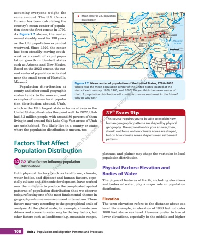
108 Unit 2 Population and Migration%u00a0Patterns and%u00a0Processesplateaus, and plains) may shape the variation in local population distribution. Physical Factors: Elevation and Bodies of Water The physical features of Earth, including elevations and bodies of water, play a major role in population distribution. Elevation The term elevation refers to the distance above sea level. For example, an elevation of 1000 feet indicates 1000 feet above sea level. Humans prefer to live at lower elevations, especially in the middle and higher assuming everyone weighs the same amount. The U.S. Census Bureau has been calculating the country%u2019s mean center of population since the first census in 1790. As Figure 7.7 shows, the center moved steadily west for 130 years as the U.S. population expanded westward. Since 1920, the center has been steadily moving southwest as a result of rapid population growth in Sunbelt states such as Arizona and New Mexico. Based on the 2020 census, the current center of population is located near the small town of Hartville, Missouri. Population distribution at county and other small geographic scales tends to be uneven, and examples of uneven local population distribution abound. Utah, which is the 13th largest state in terms of area in the United States, illustrates this point well. In 2022, Utah had 3.3%u00a0 million people, with around 80 percent of them living in and around Salt Lake City. Vast areas of Utah are uninhabited. You likely live in a county or state where the population distribution is uneven, too. Factors That Affect Population Distribution 7-2 What factors influence population distribution? Both physical factors (such as landforms, climate, water bodies, and disease) and human factors, especially culture and economic development, have worked over the millennia to produce the complicated spatial patterns of population distribution that we observe today, reflecting one of the most fundamental themes in geography %u2014 human%u2013environment interaction. These factors may vary according to the geographical scale of analysis. At the global scale, for example, climate conditions and access to water may be the key factors, but other factors such as landforms (e.g., mountain ranges, AP %u00ae Exam Tip This course requires you to be able to explain how human geographic patterns are shaped by physical geography. The explanation for your answer, then, should not focus on how climate zones are shaped, but on how climate zones shape human settlement patterns. Washington D.RichmondSpringfieldCincinnatiLouisvilleSt LouisChicagoColumbusCharlestonIndianapolisPittsburgh PhiladelphiaMISSOURIARKANSASIOWAKENTUCKYTENNESSEEILLINOISWISCONSINMICHIGANINDIANA OHIOPENNSYLVANIANEW YORKMARYLANDDELNEWJERSEYNORTHCAROLINAVIRGINIAWESTVIRGINIAATLANTICOCEAN40%u00b0N35%u00b0NLake ErieLake MichiganMississippi R.Ohio R.APPALACHIANMOUNTAINS2000 2010 202019901980 19701960 194019301920191019001890 18801870 1860 18501840 183018201810 1790 18001950Washington D.C.RichmondSpringfieldCincinnatiLouisvilleSt LouisChicagoColumbusCharlestonIndianapolisPhiladelphiaNew YorkPittsburghMISSOURIARKANSASIOWAKENTUCKYTENNESSEEILLINOISWISCONSINMICHIGANINDIANA OHIOPENNSYLVANIANEW YORKMARYLANDDELAWARENEWJERSEYNORTHCAROLINAVIRGINIAWESTVIRGINIA 0 500 50100 Miles100 Kilometers0 300 600 Miles0 300 600 KilometersArea of mapChicago IOWALake MichiganChicago IOWAWISCONSINMICHIGANMean center of U.S. populationState borderFigure 7.7 Mean center of population of the United States, 1790%u20132020. Where was the mean population%u00a0center of the United States located at the start of each century: 1800, 1900 , and 2000? Do you think the mean center of the U.S.%u00a0population distribution will continue to move southwest in the future? Why%u00a0or%u00a0why%u00a0not? %u00a9 Bedford, Freeman & Worth Publishers. For review purposes only. Do not distribute.
