
Page 77 - 2024-bfw-wiesner-hanks-ahws14e-proofs
P. 77
20°E
0
Printing centers with 10°W 0° 60°N 10°E 20°E
NORWAY
1350–1550 What new ideas were associated with the Renaissance? 59
date of establishment
SWEDEN
15th century
c
ockholm
c
c
16th century SCOTLAND Stockholm
C
1483 83
3
3
3
Political boundaries Edinburgh
in 1490 1507 North
IRELAND Dublin Sea DENMARK Baltic c
p p
0 1551 Copenhagen Sea 30°E
30°E
0
50°N
ENGLAND 1493
300 miles
0
150
Oxford Lübeck 1475 0 0 150 300 miles
d d
1478 Amsterdam Emden Hamburg 1491 0 0 150 0 300 kilometers
1554
300
kl
London 1480 1523 Deventer 1477HOLY
Utrecht 1472 ROMAN Berlin
Bruges 1474 Antwerp 1470 EMPIRE 1540 POLAND
Brussels 1474 Cologne 1466 Leipzig
ATLANTIC Gutenberg Bonn 1543 1481 Wroclaw 1475 N
Frankfurt 1478
OCEAN establishes Mainz Bamberg Kraków 1474 E
first printing
7
Paris press, 1448 4 1460 Nuremberg Prague 1478 W
1470
Strasb bourg Rhine R. 1470 S
b b
1460 A A Augsburg 1468
FRANCE Basel 1462 Munich h
Cluny 1483 Bern Zurich 1482 Vienna Buda
1482
d
1525 1 1508
A A
Lyons 1473 Geneva Milan Venice 1473 HUNGARY MOLDAVIA
Copyright © Bedford, Freeman & Worth Publishers.
1478
SubiacoPublishers.
PORTUGAL Madrid ARAGON Florence PAPAL C E Danube R.
R
1552
E
N
For review purposes only. Not for redistribution.
0
40°N L L L L NAVARRE Rhône R. 1470 V E 1469 9 I Belgrade
1471
ATES
Lisbon 1499 Barcelona STA OTTOMAN
Distributed by Bedford, Freeman & Worth
1489 CASTILE 1475 EMPIRE
Rome 1465 Constantinop p p ple
Valencia 1467 essalonica 1488
1473 1515
Naples NAPLES
1471
GRANADA Uncorrected proofs have been used in this sample.
R Reggio di Calabria
M e d i t e r r a n e a n S e a
1480
AFRICA
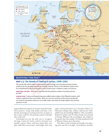
MAPPING THE PAST
wieswest14e_12_m02_32988 Growth of Printing in Europe Map positioning guide
First Proof Type block map
MAP 2.2 The Growth of Printing in Europe, 1448–1554 Bleeds top and right
Trim: 48p0 x 36p6
The speed with which artisans spread printing technology across Europe provides strong Align top map trim at top page trim
evidence for the growing demand for reading material. Presses in the Ottoman Empire were Position left map trim at type block
first established by Jewish immigrants who printed works in Hebrew, Greek, and Spanish. Extra map area on bleed side will be cropped
analyzing the map What part of Europe had the greatest number of printing presses
by 1554?
connections France and England became unified nation-states in the fifteenth century, with
national capitals at Paris and London. What are now the countries of Germany and Italy did
not unify but remained collections of smaller states. How does this help explain why printing
spread as it did?
copy, professional copyists writing by hand and wood- paper, setting themselves up in business (Map 2.2).
block printers, along with monks and nuns, were Historians estimate that, within a half century of the
already churning out reading materials on paper as publication of Gutenberg’s Bible in 1456, somewhere
fast as they could for the growing number of people between 8 million and 20 million books were printed
who could read. in Europe. Whatever the actual figure, the number is
Gutenberg was not the only one to recognize far greater than the number of books produced in all
the huge market for books, and his invention was of Western history up to that point.
quickly copied. Other craftsmen made their own The effects of the invention of movable-type print-
type, built their own presses, and bought their own ing were not felt overnight. Nevertheless, movable
59
04_howsap14e_48443_ch02_044_079.indd 59 12/10/23 1:43 PM